


Biddeford Savings Puts ET on the Map(s)
By Scott Marcoux
[Note: This article appeared in the Late Fall 2013 Newsletter. The full newsletter can be viewed in this pdf document]
 An off-road greenway is of little use to travelers without a way for them to navigate it, right? The ETA is continuously looking to disprove the local adage that “you can’t get there from here” [add appropriate downeast accent] with additional tools to show trail users where they are, and where they are going.
In addition to various resources available on our website, and our popular full-color Trail Guides, the ETA this year introduced a quick trifold map that outlines all the completed off-road sections of the ET. Better still, it is free because it is fully funded by Biddeford Savings Bank.
The bank provided full funding for the printing of 10,000 maps, which trail users snapped up from trail kiosks almost faster than we could restock them. The maps went so fast and proved so helpful to trail fans that we found ourselves wanting more.
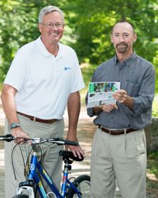
 “We couldn’t be more pleased to partner with Biddeford Savings on our map initiative,” said ETA president Bob Hamblen. “The public was immediately sold on the maps, so much so that we went through the first printing in a matter of months. Biddeford Savings stepped up and agreed to fund a second printing.”
Along with the map effort, Biddeford Savings also provided support for The Saco Bikes for Kids campaign, an effort sponsored by the Saco Parks and Recreation Department to promote healthy lifestyles and the use of the ET by area youth. A total of 46 contributors provided funds to purchase 25 new bikes and equipment for local children.
“At Biddeford Savings, we help define the path to prosperity for our customers,” said Charles Petersen, bank president and CEO. “And prosperity can come in many forms. When we were approached by the Eastern Trail Alliance to support the printing of the maps, we thought it was an excellent way to demonstrate how we put concepts into practice. The Saco Bikes for Kids campaign also seemed like a perfect fit to encourage healthier lifestyles. By using the Eastern Trail, people of all ages will prosper by enjoying the healthful benefits of the outdoors in our beautiful coastal region. The Eastern Trail is truly a gem that we want everyone to discover.”
Many thanks to Biddeford Savings to helping us to point the way for trail users. To learn more about where we’ve been in building the trail, and where we’re going, visit www.easterntrail.org today.
Share this Story: