Maine Lighthouse Ride Route Maps and Cue Sheets :
- 100 mile ride: Route Map – Cue Sheet
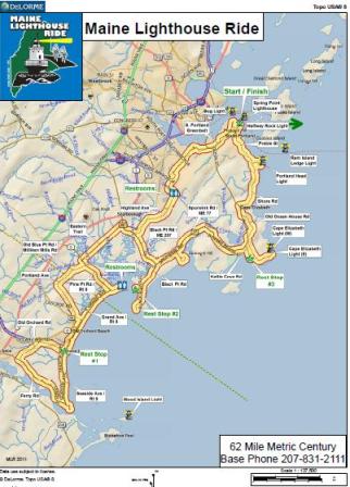
- 62 mile ride: Route Map – Cue Sheet
- 40 mile ride: Route Map – Cue Sheet
- 25+ mile ride: Route Map – Cue Sheet
|
LIGHTHOUSE INFORMATION (from south to north) |
||||
|
Lighthouse |
Observed from: |
Construction |
Height |
Comments |
| Goat Island Light | CapePorpoise |
1859 brick |
25 ft |
First station established 1833. 46 shipwrecks 1865-1920. |
| Wood Island Light | Prouts Neck and HigginsBeach, Scarborough (5 mi) |
1858 granite |
71 ft |
Pub and distillery on island in 1870’s; German submarine attempted to surrender here in 1940’s. |
| Cape Elizabeth Light (East) | Two Lights Rd.
CapeElizabeth |
1874 cast iron |
67 ft |
East and west lights used by vessels to align themselves properly in channel to Portland Harbor. Most powerful light in Maine. |
| Cape Elizabeth Light (West) | Two Lights Rd.
CapeElizabeth |
1874 cast iron |
67 ft |
Inactive since 1924; private property. |
| Portland Head Light | FortWilliams,
CapeElizabeth |
1791 granite w/brick lining |
80 ft |
Commissioned by George Washington; tower lowered and raised 4 times; inspiration for Longfellow poem; museum inside. |
| Ram Island Ledge Light | FortWilliams,
CapeElizabeth (1 mi) |
1905 granite |
72 ft |
Ledge is completely covered at high tide, which made construction difficult. 699 4-ton granite blocks quarried in Vinalhaven. |
| Halfway Rock Light | FortWilliams,
CapeElizabeth (10 mi) |
1871 granite/brick |
76 ft |
Halfway between Cape Elizabeth and CapeSmall. Visible from high ground at FortWilliams on clear day. |
| Spring Point Ledge Light | Spring Point Shoreway,
South Portland |
1897 brick/cast iron |
54 ft |
Originally was 300 yd off shore to mark dangerous ledge. Breakwater built in 1950. |
| Portland Breakwater Light
(Bug Light) |
BugLightPark
South Portland |
1875 cast iron w/brick lining |
26 ft |
Originally at end of ½-mile breakwater. Land filled in to build Liberty Ships during WW II. |


