


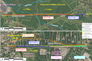
 The study’s purpose is to assess the feasibility of two new segments of the Eastern Trail extending from Route 9 in North Berwick to Perry Oliver Road in Wells, and from Alfred Road to Route 35 (Alewive Road) in Kennebunk. The focus of this second public meeting was to share the alternatives developed for the study area limits, review the preferred treatments determined by the Technical Advisory Committee, and solicit input from the community on the preferred alternatives.
A copy of the Study Area Map is available – click here to view or download this map.
Links to Meeting Resources:
- Study Area Map (pdf format)
- Meeting Presentation Slides
- Meeting Recording
This is the second public meeting held for the Eastern Trail Feasibility Study for this particular area. Go here to view the meeting resources for the first meeting (held 11/4/2021).
The final Feasibility Study Report was released May 19, 2022 – go here to review that report.