By Aislinn Sarnacki, BDN Staff Posted Aug. 29, 2012,at 1:20 p.m.
 Exiting the train in Portland, Philip McGranahan and his wife Marjorie Foote donned helmets, righted their bicycles and headed south on the East Coast Greenway, a route that would lead them along off-road paths and low-traffic roads all the way to Saco.
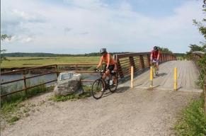
The Kittery couple pedaled the bike-friendly path several years ago — they couldn’t agree on exactly how many — but as they followed the ECG signs, they noticed that much of the route has changed. In Scarborough Marsh, where a pedestrian bridge opened to the ECG in 2004, they paused and noted that the marsh hadn’t been a part of their previous trip.
Though they ended their day in Saco, the ECG extends much farther. Through Maine, the route currently extends about 380 miles from the Canadian border in Calais to the southern tip of the state. From there, the route continues to the tip of Florida, threading together 16 states.
“The trail is actually intended to connect the communities of Maine so a traveler can see everything from historic mills in Calais, to dam sites in Lewiston, down to the largest chair down in Eliot, Maine,” said Tony Barrett, member of the Maine East Coast Greenway committee. “And the route goes right by the Paul Bunyan statue in Bangor.”
Much of the off-road sections use existing multiuse trails or have been constructed along old railroad beds.
Sections of the ECG in Maine:
• Eastern Trail: Kittery to South Portland, 68 miles.
• Casco Bay Section: South Portland to Brunswick, 35 miles.
• Coastal Route: Brunswick to Belfast to Bucksport, 125 miles.
• River Route: Brunswick to Bangor to Bucksport, 160 miles.
• Down East Route and Down East Sunrise Trail: Bucksport to Calais, 140 miles.
The East Coast Greenway Alliance, founded by 10 trail advocates in 1991, now has partnerships at the local, state and national levels.
Article continues in full here
Share this article:


0 comments
Write a comment