


The Railroad Corridor
The Eastern Trail is being built along the old Eastern Railroad Corridor. The Eastern Railroad was the first railroad to connect Boston to Portland, operating from 1842 until 1945.
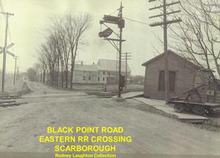
The Portland, Saco and Portsmouth RR Line was the first railway from southern Maine to Boston. Starting operations in 1842, its tracks ran from a station on Commercial Street in Portland, across the Fore River to South Portland, then south to Scarborough, Saco and finally to North Berwick, where it connected to the Boston and Maine railway.
In 1872, the Eastern Railroad bought out the Portland, Saco and Portsmouth RR Line.
The Portland Electric Railroad Company connected a trolley line with the Eastern RR to give tourists arriving in Portland direct access to the “Grand Beach at Old Orchard. See story on this by Jim Bucar in the Spring 2012 ETA newsletter, page 4.
I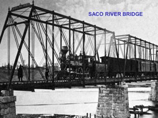 n 1945, after over a century of service, the Boston & Maine Eastern Line suspended train service from Kittery to Portland. In 1965 Portland Gas Light purchased much of the abandoned right-of-way and installed a natural gas pipeline, a use that continues today. Unitil, a New Hampshire-based public utilities company, acquired the line and most of the right-of-way in 2008.
The Recreation/Transportation Greenway
In 1991, the dream of a recreation-transportation trail offering public access— particularly to hikers and bikers—coalesced into the formation of the East Coast Greenway Alliance (ECGA). The ECGA, dedicated to the development of a continuous, traffic-free trail from Florida to Maine, links 25 major eastern seaboard cities and offers its users a multitude of historic and scenic experiences.
Maine, however, had already given expression to this vision. In 1973, the Planning-Research Division of the Maine Bureau of Parks and Recreation published a study of B&M’s abandoned rail right-of-way and its potential use as a trail from South Berwick to Scarborough – ending before the marsh at Pine Point Rd. That study found most of the right-of-way in “good” condition.
In December 1997, a few local outdoor conservation enthusiasts active in developing hiking trails in Scarborough, Saco and Old Orchard Beach, united in their desire to create a trail on the abandoned rail corridor between Scarborough Marsh and Route 1 in Saco. They had no expertise, no money, no organization— only enthusiasm, energy, and a “why not?” attitude. Therefore, undeterred by unknown obstacles, they inquired of Granite State Gas Transmission [then right-of-way owner] about access to the right-of-way and were rewarded by a favorable response from GSGT’s president: “As a pipeline operator, Granite has minimal above ground facilities and would not object to use of its right of way for passive recreation.”
In January 1998, these volunteers showed up, unannounced, at a USM public Bicycle Coalition of Maine (BCM) meeting to pitch their trail idea. Quite unexpectedly, not only the Coalition but also other participants— representatives from the Maine Department of Transportation (MaineDOT) and the Maine Office of the National Park Service Rivers, Trails, and Conservation Assistance Office (NPS-RTCA) — immediately endorsed their proposal.
Thus, the Eastern Trail group decided to organize to take advantage of the groundswell. In March 1998, the group now called the Eastern Trail Alliance (ETA) held its first public meeting, still focused on their modest proposal for a Scarborough-Saco trail. But interest and letters of endorsement from Arundel and South Portland, which was hoping to develop a trail from Bug Light to Scarborough, widened their ambitions. Further, a 1998 full page story published in the Maine Sunday Telegram provoked wider attention and interest from other communities, who sent representatives to ETA meetings. By 1999, all the activity and publicity attracted the attention of the ECGA, who decided to hold its Second Annual Members Meeting that September in . . . South Portland! The ECGA recognized that what was happening spontaneously in Southern Maine was precisely the kind of local/regional activity that could make their national dream a reality.
First, the founders of the ETA had to find how to translate their contagious regional enthusiasm into the pragmatic strategies that would turn dreams into grounded reality. Valuable advice came from the MaineDOT: ETA could not hope for financial or project support from state or federal sources until it incorporated with representatives from the towns the trail would cross if it followed the path recommended in the 1973 study. With the advice and participation of MaineDOT, the Southern Maine Regional Planning Commission, and the NPS-RTCA, ETA was able to define and codify an organization with a governing board of representatives from each municipal government and the ETA. The official result was the Eastern Trail Management District (ETMD).
Several projects and milestones have followed:
 ETA incorporated as 501(c)(3) non-profit
- Engineering Feasibility Study published
- ETMD founded as all twelve towns and ETA approve proposed bylaws and agree to pay dues to ETMD.
- The first version of this ETA web site is created in 1999 to communicate the Eastern Trail vision regionally, state-wide and nationally. The site wins American Trails’ best local trail website award in 2003
 ETA incorporated as 501(c)(3) non-profit
2004 – 2010
 2004 – September – Inaugural “8 Lighthouse Ride” staged and within a couple of years becomes the primary source of operating revenue for the Eastern Trail Alliance. The event is later renamed “Maine Lighthouse Ride,” and in some years hosts up to 1,200 bicycle riders over a course stretching from South Portland to Kennebunkport. November – A prefabricated steel footbridge is installed over the Dunstan River connecting the north and south portions of the Scarborough Marsh.
2005 – South Portland Greenbelt completed to Wainwright Fields
2006 – Spur opened in Scarborough from Nonesuch River bridge abutment south to Eastern Road; South Portland-Scarborough Feasibility Study published
2008 – A 1.6 mile segment of trail from Pine Point Road, Scarborough to Old Blue Point Road in Old Orchard Beach is completed.
2009 – Funded design of Old Orchard Beach-Saco section
2010 – Kennebunk-Arundel-Biddeford section opened
2011 – 2016
2011 – A 300 foot, twin-span prefabricated footbridge is installed across the Maine Turnpike about half a mile north of the Kennebunk service plaza. The bridge is the most visible sign of the Trail’s latest extension: a 6.2 mile segment between Southern Maine Health Care in Biddeford and Rte. 35/Alewife Road in Kennebunk. A ribbon cutting is held featuring 400 students from Kennebunk Elementary School, a bagpipe player and Miles the Moose.
A 4.37 mile segment from Old Blue Point Road, OOB to Clark Street (next to Thornton Academy) in Saco is completed. A key piece is a prefabricated bridge spanning 127 feet installed over Route 1. When it was officially opened the following spring, the bridge was dedicated as the “John R. Andrews Bridge” in honor of the Eastern Trail’s founder.
2012 – A $4.1 million fund-raising campaign, titled “Close the Gap,” is launched to fund completion of a 1.6 mile segment from the Wainwright Athletic Complex in South Portland to the Nonesuch River in Scarborough. This campaign proved to be extremely complex in terms of getting permission of landowners and the design and construction of a bridge to cross the CSX/Amtrak rail line. Construction of this segment began in the summer of 2025.
2013 – The Southern Eastern Trail Alliance, a subcommittee of the Eastern Trail Alliance, is created to further increase awareness of the Eastern Trail in the areas south of the developed off-road trail which presently ends at State Route 35 in Kennebunk. Also in 2013, the 10th annual Maine Lighthouse Ride sells out for the first time with 1000 registered riders
2014 – The Eastern Trail Alliance conducted a study and published its first Economic Impact Study, authored by John Andrews, based on a survey methodology developed and tested by the Pennsylvania-based Rails-to-Trails Conservancy specifically to monitor and measure the economic impact of rail-trails.
2016 – The first water fountain and water bottle fill-up station is installed on the trail in Saco just off Mill Brook Road.
2017 – 2022
2017 – The founder of the Eastern Trail, John Andrews, passes away in February. Read about his legacy here. The inaugural John Andrews Memorial 5K Walk/Run is held to honor John and all he has done for the Eastern Trail. Over 100 people came out to run, walk, volunteer, cheer and otherwise support the event.
The Eastern Trail Alliance reaches its $4.1 million fundraising goal for the “Close the Gap” campaign to build two bridges in Scarborough that will complete 16 miles of uninterrupted, off-road trail from downtown Saco to Bug Light Park in South Portland. The largest fundraiser in the alliance’s 18-year history was topped off with an additional $500,000 pledge made at the end of the year from the Maine Department of Transportation.
2018 – The Eastern Trail Alliance announces its new Blazing the Trail South campaign. When complete, Blazing the Trail South will add 19 miles and extend a current 6.2 mile off road section of the ET providing over 25 miles of off road trail connecting 7 communities in the most densely populated region in the state (Greater Portland, Cumberland and York Counties) providing a safe and convenient facility for bicycle commuters, recreational riders, walkers, and wheelchair users, for transportation, health and enjoyment. Read more about this campaign here.
The Eastern Trail Economic Impact Study is republished with new data collected from surveys taken on the off-road sections of the Eastern Trail between 2017 and 2018. The total count of trail users: 251,978. Significant benefits from the trail include spending by trail users on local businesses, physical and mental health benefits, and eco-tourism by many from away visiting the trail and spending money locally. Read the whole report here.
2019 – The “Over The River” trail development campaign is announced. The Cities of Saco and Biddeford are actively seeking alternatives to the current on road route between their two off road trail segments. The preferred route to take the trail Over the River would be to utilize the existing rail corridor and bridge over the Saco – currently owned and operated by Pan Am.
The “Through the Woods” trail development campaign is announced targeting an 18-mile section from Kennebunk through South Berwick. Unitil, the corridor owner, has provided us with a letter of intent for an easement which would grant access for the trail to be located within their right of way. Several local businesses and organizations have sent in letters of support. Many thanks to our two large donors, The Craig Family Trust and the Caiazzo family! Their collective $100,000 contribution helped us launch a fundraising campaign similar to the successful one for Close the Gap. To date, through their support plus donations from Pratt & Whitney, five foundations, the towns of Wells & Kennebunk, Maine DOT and several individual donors, we have raised over $250,000 towards the design and survey for the 10 miles from Kennebunk through Wells and past Pratt & Whitney in North Berwick.
2020 – Changes are made to allow continued use and enjoyment of the trail in the midst of the COVID-19 pandemic. Social distancing while getting outside is encouraged, and group running and biking events such as the Maine Lighthouse ride being held virtually.
2021 – Feasibility Studies for key new development sections of the trail make significant progress. Public meetings are held related to feasibility studies in both the “Over the River” Biddeford-Saco section, and the “Blazing the Trail South” section in North Berwick, Wells, and Kennebunk.
The most recent economic analysis of the Eastern Trail is completed, highlighting a total annual economic impact of $44.6M associated with Eastern Trail use between its northern terminus in South Portland and the state border in Kittery.
2022 – Rails-to-Trails Conservancy (RTC), the nation’s largest trails organization, inducts the Eastern Trail into its Rail-Trail Hall of Fame—an exemplary group of rail-trails nationwide celebrated for the social, economic and quality-of-life value they bring to the communities they serve. As the first Hall of Fame rail-trail in Maine, the ET was selected by national public vote from among three worthy nominees.
ET Feasibility study for Kennebunk, Wells and North Berwick completed in May 2022.
Feasibility complete, pending engineering design, for the “Over the River” Biddeford-Saco section, 3.1 miles which will connect existing portions of the trail 15 miles north of Saco and 6 miles south of Biddeford.
2023 – Present
2023 – A new campaign is launched. Berwicks to the Border is a 16 mile section includes North and South Berwick, Eliot, York and Kittery. Feasibility study work started in summer 2023.
$4 million in federal funding is awarded in June 2023 by the U.S. Department of Transportation toward construction of the Eastern Trail from Kennebunk to North Berwick. The required $1 million match will be split between the ETA and the Maine Department of Transportation.
A feasibility study to define an off-road route from South Berwick to Kittery/York begins, made possible through the generosity of a private donor who provides $130,000. That donation is also used to leverage a similar amount through a MaineDOT Planning and Partnership Initiative (PPI) grant.
The Eastern Trail Alliance hires a full time Trail Manager to maintain the trail and help develop programs for active engagement with the trail.
2024 – Three active trail expansion projects including persistent efforts to close the gap between South Portland and Scarborough; engineering design on 0.7 miles of new trail in West Kennebunk and 2.0 miles in Wells and North Berwick, and an ongoing initial feasibility study from North Berwick to Kittery.
850 Maine Lighthouse Ride participants, representing 33 states and spanning the ages from 10 to 87, sold-out this event and raised significant resources for the Eastern Trail Alliance to invest into the trail.
20 miles of off-road trail maintained and preserved including routine monitoring and maintenance, and in response to increasingly extreme and unseasonable winter weather.
2025 and Beyond: Construction is officially underway on the long-anticipated Close the Gap project in Scarborough. Still more miles left to design and build as we continue to make great progress! The Eastern Trail Alliance will continue to support the maintenance and use of the Eastern Trail many miles of greenway sections that are already completed.
Suggested sources for additional reading: