By Jack Beaudoin, Portland Press Herald – Thursday, February 12, 1998
Anybody who has ever tried to bike from Kittery to Portland knows one thing for certain: If you value your life, you can’t get there from here.
That’s because the world’s most pedestrian-unfriendly, bike-unfriendly road – Route 1 – dominates the north-south corridor through York County.
Overburdened by seasonal tourist traffic, narrow through the shoulders, rutted and pot-holed, Route 1 cuts across just about every other road in coastal York County and serves as a real barrier to safe alternative transportation and recreation.
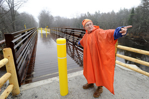
But John Andrews, chairman of Saco Trails, may have found a way around it – the Eastern Trail. In his dream, the Eastern Trail provides a lush, beautiful four-season corridor for cyclists, hikers, inline-skaters, cross-country skiers and snowshoe enthusiasts to travel.
The best thing about Andrews’ dream is that the trail already exists.
You might know the Eastern Trail by its old name, the Boston and Maine Eastern Line. Until 1945 – the year it was abandoned – trains ran the 50-mile stretch of the Eastern Line from South Berwick to South Portland. Since then, the line has remained mostly dormant, an overgrown scar cutting across the heart of York County.
But Andrews plans to bring the Eastern Line back to life. Along with Alan Cone of Saco Trails, Dick Roberge of Old Orchard Beach Trails, Tom Daley of the Scarborough Conservation Land Trust and public officials from Saco to South Portland, Andrews has managed to secure almost all the approvals needed to complete the northern edge of the trail from Route 1 in Saco to Bug Light in South Portland.
With that part of the job steaming toward completion, the committee has turned its sights on the southern stretch, from Saco to Dover, N.H.
“I don’t see why this can’t be done in a matter of years,” says Andrews, a 61-year-old semi-retired engineer with a penchant for hiking, biking and cross-country skiing. “I believe if you get a bunch of people together in these southern communities, the trail will happen.”
In fact, the speed of the Eastern Trail’s development is nothing short of astonishing. Although Daley has been looking into the project’s feasibility for 11 years, Andrews and his conservationist friends formed an exploratory committee just about three weeks ago. Since then, Granite State Gas Transmission Inc. (which owns a natural gas pipeline on much of the proposed trail) has enthusiastically signed on to the project, as has the town of Arundel.
“We’ve already talked a lot about it,” says Arundel Planner Roger Cole, who has passed Andrews’ plans southwest to Kennebunk planners. “Who wouldn’t, with a corridor like that? The Eastern Line is just there for the using.”
According to Cole, the Eastern Trail would be a boon to residents and visitors alike. And if Andrews has his way, people could be coming to the state from as far away as Florida. Andrews has been talking to representatives of the East Coast Greenway project, a trail system that someday will connect Bar Harbor to Key West.
Parts of the Greenway, like the Eastern Trail, would be off-limits to motorized vehicles while other stretches would cut through the center of cities like Boston and New York. The more access, the Greenway philosophy goes, the better.
“It’s not their intention to make this an Appalachian Trail for bikes,” Andrews says. “They want it to go where the people are. And if that means going through cities, so be it.”


 The
The 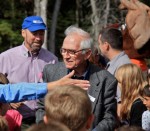 “Andrews, a retired engineer, served as founding president of the Eastern Trail Alliance until last summer. For 15 years, he led the effort to create a multi-use trail from Kittery to South Portland. Along the way, he secured funding, convinced municipalities to work together, won support from politicians and overcame many other obstacles. The trail now extends for nearly 21 miles in southern Maine.